

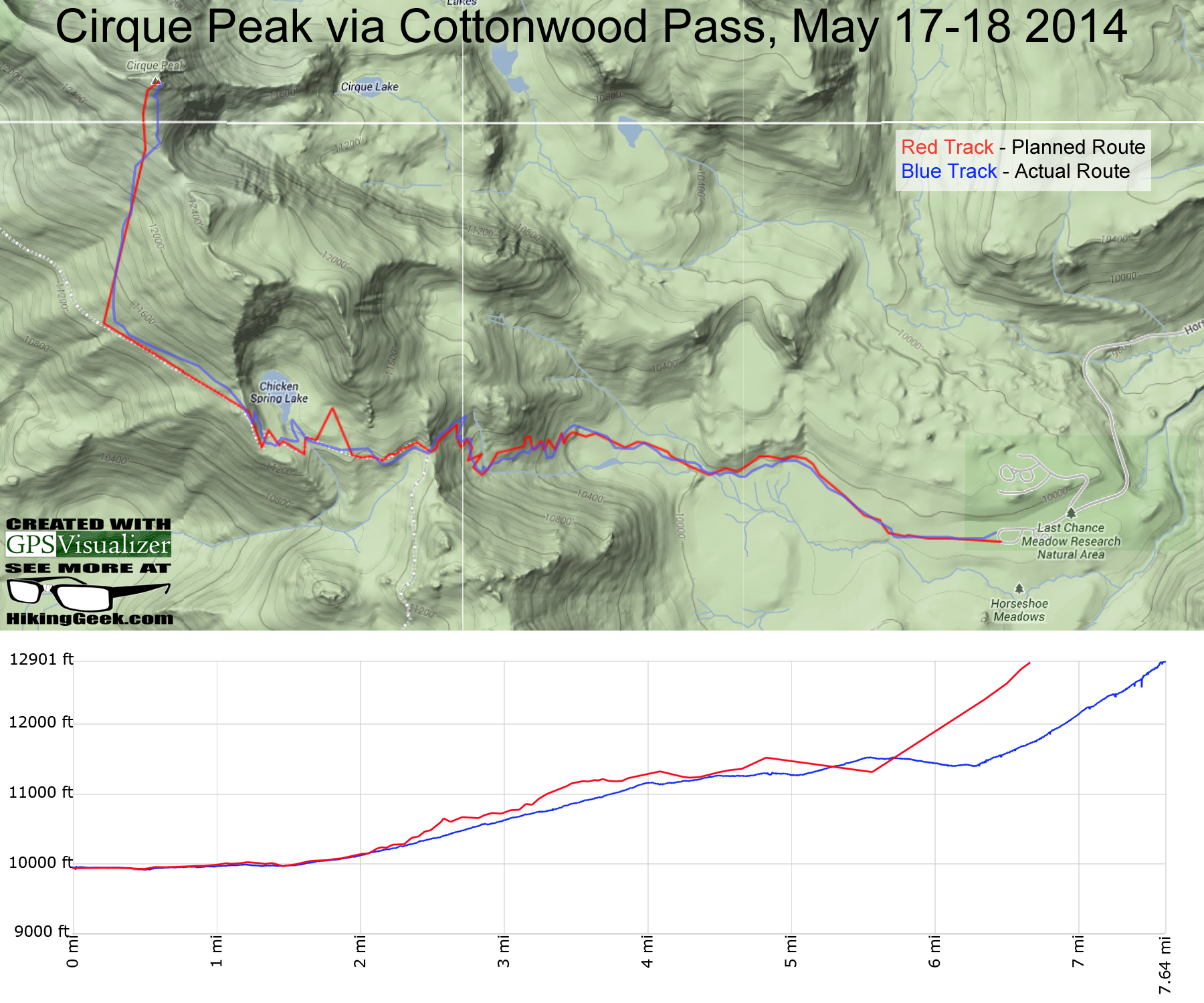
The Plan
A couple of days before the hike, I determined that taking Cottonwood Pass Trail would give us the best shot of reaching the summit of Cirque and/or Langley. The plan was to hike to camp on Day 1, get to bed early, then summit Cirque Peak for sunrise on Day 2. At that point, based on how we felt, we would decide what would come next.
The Outcome
The trip got off to a great start (left on time, made good time on the drive up, etc), but after only being on the trail for a couple of hours, it became apparent that this wasn’t going to go exactly as planned. In the end, all of us had some (somewhat) surprising issues with the elevation and only half the group reached the summit of Cirque. Here are the details:
Day 1 – Cottonwood Lakes Trailhead to Chicken Spring Lake


Once we made it to Chicken Spring Lake, we set up camp. We had originally planned to spend some time looking for a cross country route to Cirque Peak that afternoon. Since we had taken so long to make it to camp and the climb was harder than expected, we decided it was more important to rest.
| If you regularly hike or backpack in California, please join our Facebook group, California Hiking and Backpacking! It’s a great place to ask questions and share your photos, trip reports and gear recommendations. |
Day 2 – Chicken Spring Lake to Cirque Peak to Cottonwood Lakes Trailhead
When I awoke on day 2, it was 28° with very little wind. Half of the group decided to forgo the summit attempt due to the temperature and/or not feeling well. After getting dressed for the hike, I was comfortable.
The hike out of the bowl that Chicken Springs Lake sits in was quite steep and I was soon peeling off layers of clothing. After climbing out of the bowl, the trail loses elevation and I already starting thinking about how tough the hike out would be – uphill and on sand. An hour or so after leaving camp, we decided to jump off of the trail and start our cross country ascent of Cirque Peak.
Until about 4:30 am, the GPS was telling us that we were on track to reach the summit before sunrise. We were only a mile away, but our pace was slowing; picking a path through the boulders and/or climbing over them was tiring. The wind had also picked up and I’d guess it was a constant 10-15 mph with gusts up to 30 mph. Around 5:00 am, I gave up on making the summit for sunrise. I was exhausted, cold and frankly didn’t care if I reached the summit at all. This feeling of helplessness and defeat had only happened to me on two other hikes. I picked out a spot on the ridge to watch the sunrise from. I pushed as hard as I could until I reached it and enjoyed the show.


Descending to Chicken Spring Lake
The hike back to camp was very difficult. On most descents, I tend to zone out and focus on just putting one foot in front of the other. Since there was no trail to follow and I actively had to figure out where to go, that was not possible. I found myself feeling winded and flat out exhausted on the way down. Realizing that I hadn’t eaten much since lunch the day before, I stopped to eat a Snickers bar that was frozen solid and tried to snack on the rest of the hike down. It took about 2 hours to hike back to camp.


Heading Back to the Trailhead
By the time we made it back to camp, I was absolutely exhausted. The hikers that stayed at camp were already packed up and ready to go (they expected us to be back much earlier. It took us about an hour to pack up and the hike back to the trailhead took about 2.5 hours. We threw the packs in the truck and headed down to Lone Pine for some well-deserved pizza.
Geek Stats

The photo gallery below will load slowly. Thank you for your patience.
The gallery contains panoramas and will load slowly. Thank you for your patience.


Joseph Gregory
I’m dying here… I can’t even…
These are excellent! It really looks like you enjoyed this trip.
evan
hey, i wanted to summit langley on june 7th? Di you make it to the top of langley? couldn’t read the marker. how was the snow? Did you need ice axe, orwere microspikes enough?
TheHikingGeek
The hike was tougher than expected and we had two people that stayed at camp, so we decided to descent after making it to the top of Cirque.
The snow we encountered was hard and icy. We were ok with microspikes, but there was a storm up there last week.