powered by Advanced iFrame. Get the Pro version on CodeCanyon.
Gil (GoHiker.com) and I hiked the High Sierra Trail to Mt. Whitney, June 17-22. Here is Day 3 of our trip:
| If you’ve hiked the High Sierra Trail or plan to do so in the future, please join our Facebook Group, High Sierra Trail! |
The Plan
- Hike Precipice Lake to Kern Hot Springs (36.478172,-118.405988)
- Precipice Lake to Big Arroyo (36.521122,-118.533683)
- 3.6 miles || +500, -1115
- passes through Kawaeh Gap (36.557395,-118.551235)
- Big Arroyo to Upper Funston Meadows (36.455497,-118.412704)
- 12 miles || +1260, -4150
- Funston Meadows to Kern Hot Springs
- 2.3 miles || +190, -75
- LEG 3 Total: 17.9 miles ||+1850, -5328 || -3478 net elevation gain || 10-12 hrs
- Precipice Lake to Big Arroyo (36.521122,-118.533683)
The Outcome
I was awake and packing up camp by 4:45 am. I wanted to make sure I spent some time stretching before we got started. When planning out our itinerary, this was the day that really stood out to me: nearly 18 miles with over 5,000 feet of downhill. The downhills always beat me up and I knew this day would be one of my toughest days ever. We were on the trail by 6:00 am, but progress was slow; I kept stopping to take photos. The reflections on the tarns between Precipice Lake and Kaweah Gap were beautiful and I figured. I also kept telling myself that a slow start would be good for my sore back and feet. After getting to the top of Kaweah Gap, we stopped so that I could make some adjustments to my pack and enjoyed the views down into the Big Arroyo.
 |
 |
 |
 |
A few minutes after we started our descent into the Big Arroyo, we were swarmed by mosquitoes – the air was black with them. We decided to use our head nets. Using a head net was something that I had ever done and I did not enjoy it. Thankfully after about 45 minutes or so, the mosquitoes disappeared just as quickly as they had appeared. The hike was uneventful all the way down to Big Arroyo Junction. As we started our ascent up the north wall, we noticed that it was already getting very warm and the wind was picking up. We also noticed that the terrain was quite dry, looking much like the trails I avoid in SoCal during the hottest days of the summer. Some of the water sources that were marked on our maps had slowed to a trickle, but we found unmarked sources along the trail.
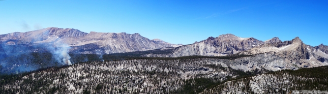
As we hiked towards Chagoopa Plateau, we had an unwelcome surprise – we spotted a fire across the valley, about 1.25 miles (as the crow flies) from where we were standing. With the strong winds, dry terrain and Gil’s prior history with forest fires (long story), we were a bit nervous. After using our Delorme InReach (provided by LowerGear.com), we decided to continue as planned. As a precaution we set our position to be sent out every 10 mins until we were well beyond the fire.
 |
 |
Video Courtesy of GoHiker.com
Soon after we spotted the fire, we hit the Chapooga Plateau. The trail flattens out here, then descends towards Kern Trench. Wanting to put as many miles as possible between us and the fire, we moved quickly. Before we knew it, we were in the path of the smoke, which did not make sense. Looking at the map, Gil realized that we had missed a trail junction and were headed towards Moraine Lake. If we stayed on this trail, it would add nearly a mile to our long day. After some discussion, we decided to cross-country it back to the correct trail. After a few minutes, we were back on track.
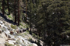
As we started to drop down into Kern Trench, we were treated to some spectacular views. Once we finally dropped all the way down into the valley, (I believe) we managed to take another wrong turn. We saw a sign that said ‘Kern Hot Springs – 1.8 miles.’ I remembered thinking that it was supposed to be 2.3 miles, but we happily followed the sign. It seemed that this path was intended for pack animals. One excruciatingly long section of trail consisted on fist sized talus and I felt as though I could twist a knee or ankle with every step. On this trail we saw something that was very surreal at the time; a group of a dozen pack mules and horses leading themselves, no human to be seen anywhere.
 |
 |
As we made it to Kern Hot Springs, it was already getting dark. In our exhausted states, we didn’t notice the wooden plugs that are used fill/empty the cement tub at the hot springs, so we didn’t soak in the tub as planned. I was so tired that I didn’t prepare hot food for dinner and I got into bed as soon as I got my bivvy set up. Laying in my bivvy, I noticed something that made me very happy. My back soreness was nearly gone – apparently the pack adjustments I had made, being more conscious of the way I was walking, and taking the time to stretch had helped my sciatic nerve pain.
 |
 |
 |
Leg 3 (as tracked): Precipice Lake to Kern Hot Springs|| 18.4 miles || +2066′, -5559′ || -3493′ net elevation gain || 14 hours
Water & Food
I drank about 120 ounces of water by noon, but once we started dropping down from Chagoopa Plateau, I stopped drinking. I went to bed feeling very dry, but didn’t want to have to get up during the night to go to the bathroom. Random thoughts on food:
- Too tired to make dinner, so I now have an extra meal if we need another day on the trail. Hopefully my energy levels will be ok tomorrow.
- I choked down 1/4 lb of “minty” macadamias.
- I was craving Triscuits and Jack Link’s Beef Sticks for most of the day, but wanted to save some for the last half of my trip.
- Since I haven’t been eating the PB & J tortillas up until this point, I put them in a baggie near the top of my pack and ate the majority of the tortillas today. They taste great, just messy.
Gear
A few notes on the gear I used.
- WoolX Merino Wool
- Merino wool ¼ Zip Baselayer Top
- Once again, I started and ended my day wearing this top. One thing that I’ve noticed is that it has an ‘athletic’ fit I think I would be more comfortable with the next size up.
- Merino Boxer Briefs
- I noticed a spot on the small of my back that is getting irritated. I can’t figure out if it’s the boxers (there’s a sewn in tag there) or my pack that is causing it. I will try a different pair of boxers on day 4.
- Merino wool ¼ Zip Baselayer Top
- Farm to Feet Merino Wool Socks
- High Points
- Dried quickly after washing them on day 2.
- I was planning to wear a thinner pair of socks on day 3, but realized that I didn’t put the extra insoles (to take up some space in my boots) in my pack. Looks like the High Points will be worn all 6 days of my hike!
- High Points
- Delorme InReach, provided by LowerGear.com’s Rental Service
- The Delorme was invaluable today. Finding out the status of the forest fire was important to us, and we also used it to get the forecast for the rest of our hike.
- Day 2 Battery Usage
- Start of Day 2
- my iPhone was at 100% (charged with solar charger)
- Delorme was at 91% (not charged since leaving the hotel)
- End of Day 2:
- iPhone was at 95%
- Delorme was at 82%
- Heavy usage – sent 14 tracking points and 24 messages, including 14 custom messages. I also marked waypoints (5 total) to show the position of the fire/smoke in relation to where we were.
- The Delorme was used for navigation.
- Start of Day 2
- Oboz Beartooth BDry Hiking Boots
- Both Gil and I had some very sore feet after all of the downhill we did. I am surprised at how sore I am and can’t imagine what my feet would feel like without the full shank these boots provide.
- On some of the downhill this morning (when I was still half asleep), they saved me from an ankle sprain twice.
- Hydrapak Stash & Nalgene Cantene
- While I had originally planned to use my Geigerrig bladder as my principle means to carry water, I found that the Stash & Cantene were more convenient due to the frequents stops to filter.
- I’ve been using the Stash for electrolyte replacement, as well as filling with water and completely drinking it (and then refilling) at each place we filter.
- Vivobarefoot Pure
- Short day after our hike was finished, so these did not get much use.
- Mountainsmith Boundary 75L Backpack
- After some trial and error, I think I’ve got the adjustments on this pack figured out.
Http iframes are not shown in https pages in many major browsers. Please read this post for details.
powered by Advanced iFrame. Get the Pro version on CodeCanyon.
The gallery below (50 photos) loads slowly. Thank you for your patience.